- Transfer technology to the private sector, as well as to other government agencies and educational institutions.
- Implement, in conjunction with other center organizations, the overall system development functions, from management, design, development, fabrication, integration, verification, and application to analysis of flight data.
- Model and develop solid-state laser systems for monitoring atmospheric species and state parameters from ground-based, aircraft, and space platforms in support of the Agency Earth Sciences Strategic Enterprise.
- Provide cross-cutting laser and electro-optics technology to other NASA enterprises including Aerospace Technology, Space Science, Human Exploration, and Development of Space Enterprises.
- Investigate and perform analytical modeling, spectroscopy, analysis and development of solid-state laser materials, components, and systems
- Manage and develop laser system electronics, detectors, optics, and signal processing.
An example of our work can be read about here, in a newspaper article covering a successful project.
What is Remote Sensing?
Remote sensing is any technique for measuring, observing, or monitoring a process or item without physically touching the item under observation.
If you are reading this you have personal experience with remote sensing.
When you observe an object you are using remote sensing. Your eyes and brain work in unison as one of the best remote sensors; you are constantly observing the objects that surround you and taking mental note of their qualities. Remote sensors that we build at NASA work the same way, but they work at massive distances and tell us things about an object that normal human eyes could not.
Optical telescopes, cameras, and radio telescopes are other types of remote sensors.
There are two classes of remote sensors:
- Passive remote sensors do not include the energy source on which the measurement is based. Examples of passive remote sensors include the eye and optical telescopes.
- Active remotes sensors do include the energy source on which the measurement is based. RADAR (Radio Detection And Ranging) is a widely known form of active remote sensing. In RADAR, the instrument emits a radio wave and senses the returned energy which was reflected from the target. Using the time delay between emission and return of the signal, divided by the speed of light, the distance to the target can be determined. LIDAR (Light Detection And Ranging) is the optical analogue of radar. LIDARs emit a concentrated light beam, such as a laser, onto the target and measures the energy reflected back to the LIDAR receiver. LIDAR also allows us to discover more about the object’s traits, such as size and shape, where as RADAR is usually more effective simply as an indicator whether an object is present or not.
Why do we do it?
We choose to utilize remote sensing for a variety of reasons, but the primary benefit is: the sensor does not need to be in contact with the substance under observation, it may observe at a distance, and because no on-site instrumentation is needed, remote sensing allows us to…
Avoid hazardous or difficult to reach regions,
- Hazardous locations include:
- The inside nuclear or chemical reactors
- Difficult to reach regions include:
- Extra-terrestrial bodies (other planets, the sun, stars, galaxies, quasars, etc.)
- Terrestrial locations (the ocean depths, mountain tops, and polar regions)
- Local areas (behind obstacles, emissions from smokestacks or moving vehicles)
Measure a process without disturbance,
- Monitoring flow around an aircraft model in a wind tunnel
- Measuring temperature during an experiment
Probe large volumes cheaply and quickly,
- Global measurements of aerosols, air pollution, agriculture, human impact on
the environment, ocean surface roughness, large scale geographic features
Smooth local fluctuations by averaging over a large volume.
- Can take massive amount of data over large distances and average it over the target area.
More information regarding Remote Sensing can be found at:
http://science.nasa.gov/earth-science/
http://earthobservatory.nasa.gov/Features/RemoteSensing
Some of our past projects
DAWN-Air: Doppler Aerosol Wind Lidar
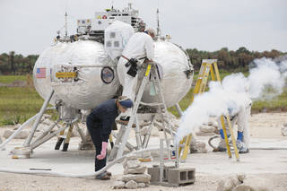
ALHAT: Autonomous Landing Avoidance Technology
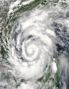
GRIP: Genesis and Rapid Intensification Mission